
Southwest National park
Is one of the best places to see on Tasmania’s Southern Edge. It is Tasmania’s largest National park sprawling across 600,000 hectares, It’s also contains some of Australia most rugged and wild lands. It is a place not to miss in Tasmania it has incredible hiking trails, amazing scenery and awesome beaches. There are no roads in the national park so transport is by boat, by foot or by planes. I have highlighted the hiking trails we explored near Geeveston and Cockle creek. For camping in The Huon valley click Here.
Exploring the South West National park
By Boat
There is a few boat charters Hobart yachts, Tasmanian boat charters and Yukon tours. All offering different boat charters some are up to 7 days click the company you’re interested in and it will take you to all the prices and charter options.
By Air
With Par Avion wilderness tours, the southwest wilderness experience which includes return flight from Hobart to melaleuca, Lunch, wine and refreshments, a scenic cruise and a guided ground tour. You can also get dropped off at Melaleuca and walk the South Coast Track back to cockle creek. Prices start from $599.
Tahune Adventures
Getting to the Tahune Airwalk by car is a 60 minutes and 61 km from Hobart, Or 28km and 30 minutes from Geeveston. Hartz Peak National Park is just off Arve road. It’s down a dirt road on the way to Tahune airwalk. The drive to Tahune Airwalk is on a sealed road. Tahune Airwalk Recently was affected by the bushfires in 2019 it has now been re built. It has some noticeable fire damage but it’s interesting to walk around noticing life coming back to the forest. Tahune airwalk has amazing walking trails and beautiful views along the trails. Entrance to the park is from $29 per adult and if you dare to do the eagle hang glider it cost $22 per adult. Another add on is the twin river adventures which is rafting down the rivers from $185 per person.

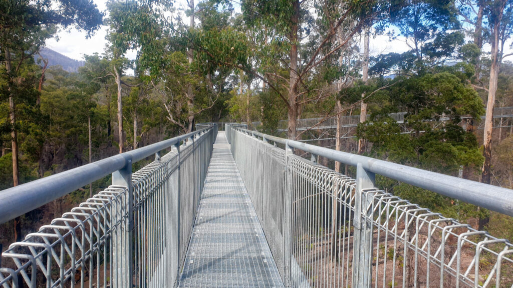
Entrance to the park
When you enter the park you will head over a bridge to the Air walk. The Air Walk is a 600 meter walkway high above the forest which lays beneath you. There is a fair few stairs to the top, then it is an easy stroll across this 50 meter high structure. You get spectacular views over the Huon river.

The Airwalk
As your walking along the airwalk you will notice a fire damaged tree that has a flat surface. People have begun throwing coins and trying to land the coin on the top of the stump. As you continue to the end of the structure. Take a left this is where you will reach a platform that suspends 50 meter from the ground. As you walk out make sure to take in the views before heading out.
Suspension Bridge walk
As you exit the airwalk take a left to the suspension bridge walk. You will pass two amazing suspension bridges over the river. The first suspension bridge is 100 meters across the Huon river.
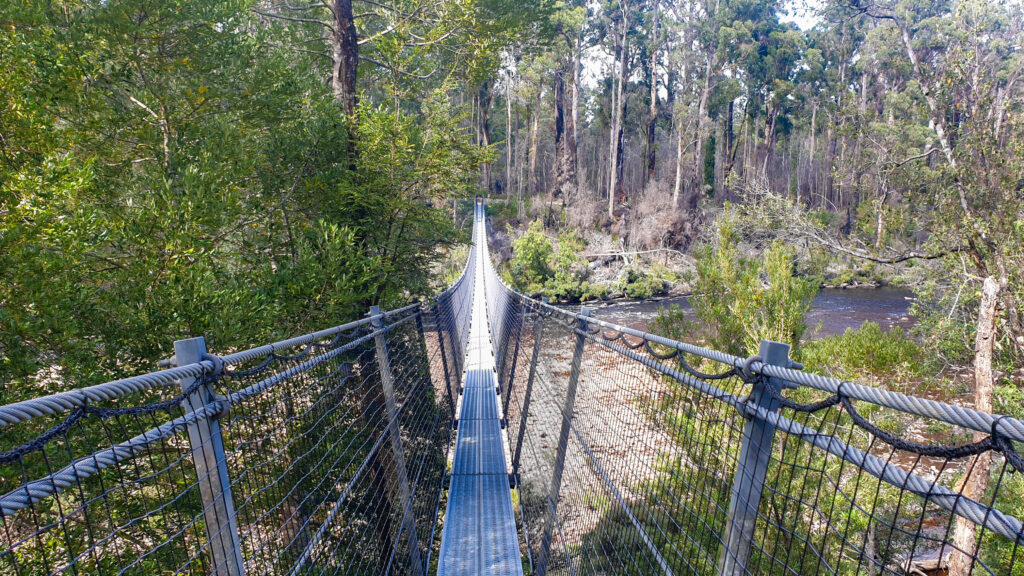
Second suspension bridge
The second suspension bridge is 62 meters across the Picton river. The swinging bridges walk takes approximately an hour to complete.

Huon Pine Walk
It is worth a detour this way back down as you will see more amazing views. The other walk at the park is Huon pine walk which is a 20 minute return walk. Following the riverbanks on a board walk through the lush forest.
Hartz National Park
Arve Fall’s
Is a 20 minute or 1km return walk, grade 2. We enjoyed a short stroll through Hartz national park following Arve river. You will get to a bridge, from here continue around the corner down some stairs. The look out is beside the waterfall. From the lookout you will get spectacular views over Hartz national park and the Arve Falls.


Waratah lookout
Is An easy 5 minute stroll offering great views of Hartz national park. The walk is 300 meters return and grade 1.
Lake Osbourne
Is a 45 minutes 2km return walk, grade 2. From the car park follow the signs to lake Osborne. This was a nice easy walk with a slight incline to the lake. At the end of the walk you will be rewarded with amazing views of the lake and the mountains in the background.

You will begin this walk by walking through the rainforests. As you emerge out of the rainforests and onto to the boardwalk you will see epic views of Hartz Peak. This is a great short walk to do at Hartz national park.

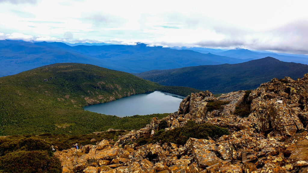
Hartz Peak
Is a 3-5 hours, 7.4km, 400m climb in elevation, grade 4.
This is an awesome walk with epic views (in fine weather).Whether you decide to just get to Lady Tarn, Lake Esperance or go all the way to the peak. A hike in Hartz national park is well worth a visit.

Lake Esperance and Lady Tarn.
We came to the National park on what was supposed to be a clear day. It turned out to be overcast and raining so we first hiked to Lake Esperance. It was cool to see the lake engulfed with clouds. It made the drive out worth it. We then came back the next day, after talking to some park rangers the previous day. They let us know the weather was looking more promising. Once reaching the peak we did have to wait for the clouds to clear but it was worth it. Make sure to bring a picnic lunch and take in the views if your going to the top. If you are short on time it is still worth a visit to see Lake Esperance and Lady Tarn.

Lake Esperance
The walk to Lake Esperance is for moderately fit walkers. It is a 2 hour, 3.4km return walk. This is a good walk as it isn’t to far and is quite a leisurely walk. When we first got to the national park we walked to Lake Esperance as the weather was overcast and raining it gave the lake a different view. In fine weather you will be rewarded with views of the glacial lakes surrounded by dolerite cliffs and views of Hartz peak.
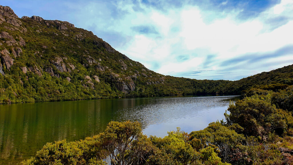
It’s quite an easy walk but has a slight incline most of the way. You will reach an altitude of 980 meters, sturdy shoes are recommended as the path is quite muddy and slippery in parts. They have now begun to build the path up with boardwalks when we were here you could notice the park rangers were replacing some of the wood walkway with raised boardwalk. Make sure to check the weather before you head up as it has very changeable weather here

Lady tarn
The walk to Lady tarn is for moderately fit walkers. It is a 3 hour, 6 km return walk. If just walking to the lakes I would combine both Lake Esperance and Lady tarn together for a day walk. Lady Tarn also is a glacier lake and worth walking to

Hartz Pass
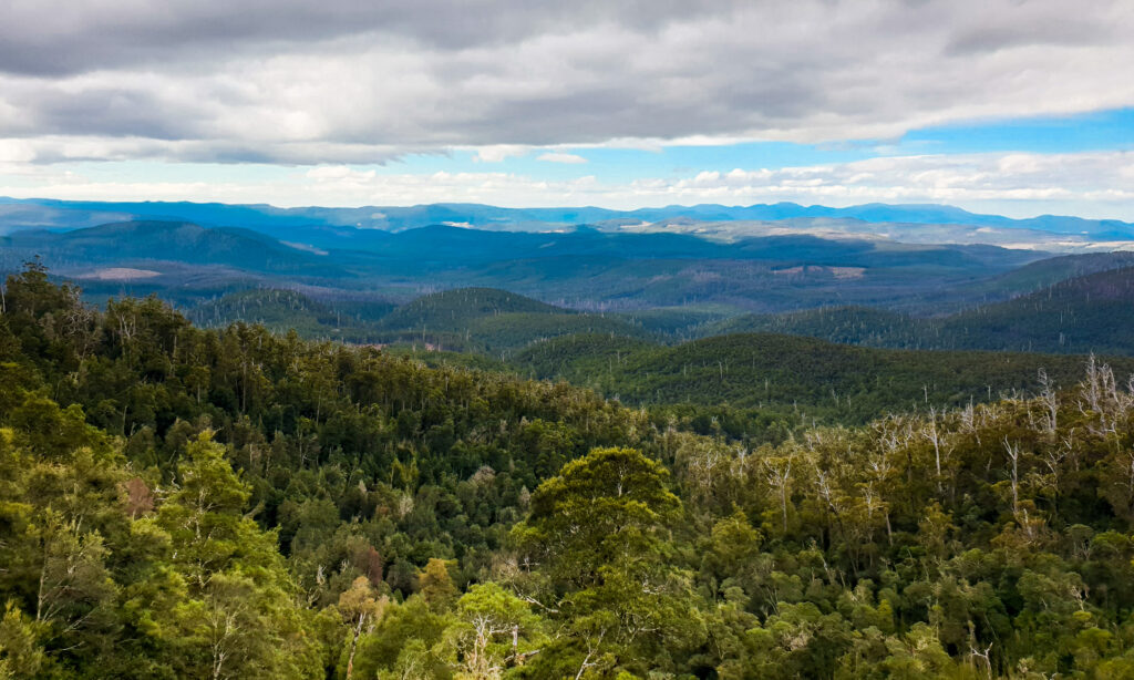
The walk to Hartz Pass is for Experienced hikers. It is 3.5 hours return, 7km return walk. It is a steep and rocky 40 meter climb to Hartz pass you will be rewarded with views of Huon Valley and south west national park and Hartz lake. You will see the views best in fine weather, reaching an altitude of 1050

Hartz peak
The walk to Hartz peak is for experienced hikers. The walk is a 5 hour, 9km return walk. I would recommend you to be physically fit as it is a steep climb to the top of Hartz peak also sturdy shoes are recommended.
If you are up for the challenge I would recommend to hike on a clear day as you will get views of Hartz lake, south west national park and you will see all the mountain peaks in the background. Check the weather and make sure there won’t be cloud covering the mountain as it will make the hike to the peak worth it. As you begin to reach the peak the trail climbs up the rocks as the path isn’t too clear kind of make your own path or follow other people all the way to the top.

Cockle Creek
Cockle creek is the farthest south you can drive its 148 km 2 hour drive Hobart. Here you will discover Pristine beaches, Distant Mountain peaks and walking trails. There is no services Or shops but there is plenty of free campsites to stay along the beaches. We choose to stay at catamaran campsite it was a nice place to set up camp. It didn’t have very level ground but perfect place to stay just off the main road. It was also close to a boat ramp where you can kayak or take your boat out. It wasn’t very far from a beach only about 2 km walk.

Catamaran Campsite
Once you reach the end of the road in Cockle creek it is about a 5 minute walk to the whale structure at Adams point. The structure is to resemble the history here in 1830’s if your lucky you may spot a wild whale during migrant season between June and September.

South Cape Bay Track
The walk takes 4-5 hours 18 km return. This track is part of the south coast track which is a 6-8 days, 83 km one way track to melaleuca. South cape bay is Australia’s most southerly track and you will reach the southernmost Point of Australia at South Cape Bay.


The southernmost Point of Australia
The track starts with a slight uphill climb going over the rocks. You will then go across ‘blowhole valley’ along a boardwalk. The path is overgrown and isn’t sign posted but the path is very clear. Once you reach the end of the path you will pass through a rainforest. Once through the rainforest you will get to a cliff top where you will get views along the south coast. From here its a short descent down steps to the beach. Bring a rain jacket and wear sturdy shoes as the weather is unpredictable and the path can get muddy and rocky at times.

Fisheries Point Trail
Is a 4km 2 hour return walk. The trail is highly recommended to take when its low tide, some of the trail disappears at high tide which makes it much more difficult. As you head towards the track there is tide times so you can plan when to go or click here to check out the tides.

Fisheries Point
The walking trail goes over the rocky headlands and along white sandy beaches with incredibly clear water. As you walk along you will be looking out to the north towards the heart of Tasmania. Make sure you keep your eyes out for dolphins, Penguins, seals and whales. As you arrive at Fisheries Point you will see ruins of the pilot station and the lighthouse. Return along the same trail back to Cockle Creek.

Duck Hole Loop
Is a 4.2km 1.5hours return walk to the lake, Grade 2. The walk is mostly along a boardwalk and follows a stream through regrowth forest to the lake, which is a Flooded sinkhole now home to platypus.
